Kingdom of Mustang
Map
Explorers such as Professor David Snellgrove and the Italian scholar Guiseppi Tucci and Michel Peissel visited Mustang in the 1950’s and it has largely been their tales of a Tibetan-like arid region locked off from the outside world that has fuelled interest in the area.
Recognising the special nature of this old, tiny kingdom, the Nepalese have imposed a surcharge for anyone wishing to trek past Kagbeni, the border of Upper Mustang. With legal trekking groups only being allowed in for the first time in March 1992, you would be part of a small privileged minority to visit this remote outpost of Nepal.
 Mustang is the old kingdom of Lo. Actually the capital of the Mustang district is Jomsom, but the real Tibetan style district lies north of Kagbeni and is usually referred to as Upper Mustang. The real capital, Lo Manthang, where the present king lives, is a fantastic square-walled town sitting on the ‘Plain of Prayers’.
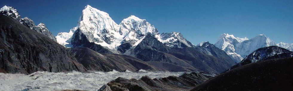
Mustang has an average elevation of 13,200ft and is located to the north of the mountain giants of Dhaulagiri and Annapurna and is therefore north of the main Himalayan range and geographically is part of the highlands of Tibet. It is a vast high arid valley, characterised by eroded canyons, colourful stratified rock formations and has a barren, desert-like appearance.
One of the most fascinating features of Mustang is literally thousands of cliff dwellings, some of which look completely inaccessible. The most recent theory is that they may date 8 – 10,000 BC when Mustang was a much greener land.
Naturally, most of the history is now a matter of legend rather than recorded fact, but it seems clear that Lo was once part of Ngari, part of Tibet and a rather loose collection of feudal domains. It was incorporated into the Tibetan Empire under the most famous of the Tibetan kings, Songtsengampo. It was an important means of crossing the Himalaya from Tibet to Nepal, and many of the old salt caravans passed through Mustang. By the 14 Century much of Ngari became part of the Malla empire, whose capital was Sinja in western Nepal. Really, it became an independent kingdom in its own right, under the rule of Ame Pal, the founder king of Lo in 1380. The present royal family can trace its history 25 generations back to Ame Pal, and the city of Lo Manthang, which we will visit, was the centre of their power.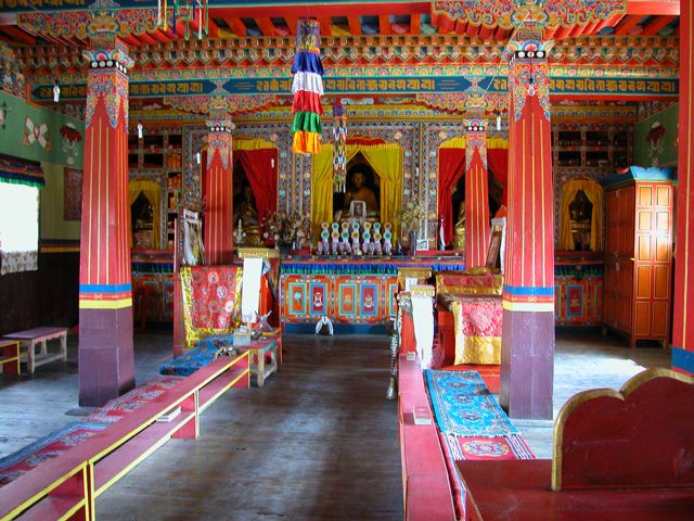
In more recent times in the 1960’s, Mustang became the centre for Tibetan guerrilla fighters who carried out small operations against the occupying Chinese. They were assisted by the CIA and the Tibetan Khampas were secretly trained in America. With Nixon’s visit to China in the 1970’s, the CIA’s support was withdrawn and the Nepalese managed to disband these resistance fighters.
PLEASE NOTE: It is possible for us to arrange a riding horse on the trek at additional cost for anyone who wishes. Please contact us if you are interested in pursuing this option.
Detailed Itinerary
ARRIVE KATHMANDU MID-AFTERNOON
Transfer to the Kathmandu Guest House, which has a large garden and outdoor patio. It is built in Nepalese style and overlooks the bustling Thamel area and the mountains beyond.
1
AT LEISURE IN KATHMANDU
This is a fascinating medieval city, its streets, bazaars, temples, shrines and Buddhist stupas crowded with peoples of every creed, colour and race. Rickshaws, taxis and hooting motorists add to the din and create that special atmosphere that Kathmandu is so famous for. The ‘hippie’ capital of the east is a great place to hang out. Overnight at the Kathmandu Guest House.
2
FLY TO POKHARA
We will take the short flight which offers sensational views of the Greater Himalaya. On arrival we will transfer to a comfortable hotel on the edge of the lake. From here Machupuchare, the Fishtail Peak, can be seen, as can Annapurna itself.
3
FLY TO JOMSOM (9,000ft) & BEGIN TREK TO KAGBENI. (9,500ft). 3. 5 – 4 hours
We take the early morning flight, usually around 7. 00am, which again will give close-up views of the Annapurna range, Dhaulagiri and nearby satellites, 20 minutes flight in a small aircraft. We will be met at the tiny airstrip by our Sherpa crew and after some initial preparing of loads and a cup of tea, start off on trek. Directly north of Jomsom is the pretty village of Kagbeni, There are about 80 families living here, most of them traders who are the link in the chain between modern Nepal and the Tibetan-type people of Mustang. Just out of Jomsom we cross a small hanging bridge and then walk along the banks of the Kali Gandaki. The trail is quite barren with craggy rocks and sand and is mostly flat, which makes it very easy going. This very easy, enjoyable start is at the same time picturesque, with views of big peaks all around such as Dhaulagiri (26,794ft), Tukuche (22,703ft) and in the west the awesome mountain above Kagbeni, Nilgiri (22,769ft). Over to the south and south-west can be seen the entire Annapurna Massif. You are more than likely to meet Indian pilgrims on their way to and from Muktinath on this stretch, and other Europeans for an hour or two who will be on the world-famous Annapurna Circuit. Upon reaching Kagbeni there is a taste of scenes to come in Upper Mustang, what with its narrow alleyways and tunnels, irrigation canals, green fields of wheat and barley and a large red gompa. At the police check-post at the north end of the village there is a sign saying ‘Restricted area, tourists please do not go beyond this point’. Here we will complete our paperwork formalities for us to enter this long-forbidden region of Nepal. ACAP have set up a very interesting information post here with displays of Mustang artefacts and photos. Camp overnight.
4
TREK TO CHUSSANG. (9,580ft). 5 hours
Sometimes it is possible to trek right up the river valley, but the best solution is to use a combination of the high trail and the river bank pathways. The trail then widens significantly revealing an endless stretch of sand, however, the path is kept interesting by the passing of several mule trains bearing goods from Mustang and probably Tibet as well. On the west bank of the river you can see Gompa Kang and some caves. Unlike most monasteries in Upper Mustang, Gompa Kang is of the Nyingmapa sect. We stop for lunch at the village of Tangbe, which is situated alongside the east bank trail above the river, at an elevation of 9,600ft. Here are the first black, white and red chortens that typify Upper Mustang. The little town is a labyrinth of narrow alleys among white-washed houses, fields of buck-wheat barley, wheat and apple orchards. Nilgiri Peak continues to dominate the southern sky-line. Chussang village is only about 1 – 2hrs walk beyond Tangbe at the confluence of the Narshang Khola and the Kali Gandaki. There are three separate parts to this village and some broken castle walls on the surrounding cliffs. Across the river from Chussang are some spectacular red organ-pipe eroded cliffs above the mouth of some inaccessible caves. The five villages of this area, Chele, Gyakar, Chussang, Tangbe and Tetang are a culturally unified group of people, closely related to the Manangis, rather than the true Lobas. Camp overnight.
5
TREK TO SAMAR. (11,480ft) 5 – 6 hours
There is a distinct change here, not only in topography, but there is a world of difference also in the culture, lifestyle and people. Settlements are more scattered, smaller and more basic. The people of Lo or Mustang do practise agriculture, but because of the lack of rain and fertile soil, cultivation is in sheltered plots of land making the landscape a pattern of brown, with scattered patterns of shaded greens. Continuing north either wading the river or climbing on the trail we reach a huge red chunk of conglomerate that has fallen from the cliffs above forming a tunnel through which the river flows. A steel bridge spans the river just in front of the tunnel and north of here the Kali Gandaki becomes impassable on foot, although locals sometimes travel this route on horseback, through a steep, narrow canyon. There are many caves here high on the fluted red cliffs above. The trek now leaves the valley and climbs steeply up a rocky gully to the village of Chele (9,940ft) amongst extensive barley fields that blanket the hillside. Most of the houses now have sheep horns above their doorways and ghost traps. Watch out also for the ferocious Tibetan mastiffs that many of the Tibetan-like people keep. Climbing from Chele up a steep spur we come to a cairn at 10,270ft. Here there is a view of the village of Gyagar across the huge canyon. The climb continues along the side of a spectacular steep canyon to a pass at 11,500ft. From here it traverses on a pleasant trail to Samar situated in a grove of poplar trees. This is a major stopping place for horse and mule caravans. Camp overnight.
6
TREK TO GHILING. (11,480ft) 4 – 5 hours
We climb above Samar to a ridge and then descend into a large gorge past a chorten painted in red, black, yellow and white and then the trail goes into another valley filled with juniper trees. We then cross the stream and climb to a ridge at 12,500ft. We cross another pass, follow a ridge and descend to Shyang Mochen a tiny settlement with a few tea shops at 12,170ft. A local person can show you the steep trail to Rangbyung, a cave with statues that ‘grow’. It is believed that if any part of the statue is broken off it will grow back by itself. We visit this cave on our return. The trail climbs gently from Shyang Mochen to a pass at 12,370ft and enters another huge east-west valley. There is a trail junction here. The left trail is the direct route to the Nyi La by-passing Ghilling. Take the right fork and descend to Ghilling with its extensive fields of barley at 11,810ft. As in all the settlements of Mustang, most houses are constructed out of mud and stones with roofs cast out of twigs, straw and a mixture of mud and pebbles, usually painted in bright white or ochre colours. Camp overnight.
7
TREK TO TSARANG (11,480ft) VIA GHAMI (11,650ft) 8 hours
From Ghilling the trail climbs gently through fields, up the centre of the valley, passing below the settlement of Tama Gun and an imposing chorten. It rejoins the direct trail and then becomes an unrelenting climb across the head of the valley to the Nyi La Pass (12,960ft). This pass is the southern boundary of Lo or Mustang itself. The descent from the Nyi La is nice and gentle. About half an hour from the pass is a trail junction; the right trail is the direct route to Tsarang, the left trail leads to Ghami. Ghami is the small village sheltered by overhanging cliffs and next to a clear stream. During the day you will pass many chortens along the way. Always keep to the left as it is bad ‘Karma’ to go the wrong way round. The afternoon is in perhaps the driest part of Mustang, and much of one’s energy is spent negotiating loose, dry soil. However, the magnificent views of the countryside, the gentle contours of the north, in contrast to the rugged mountains in the east and west, are a source of inspiration. 4 hours walking brings us to Tsarang, a large spread-out village inhabited totally by Lobas. Tsarang is a maze of trees, willow fields and houses separated by stone walls, at the top of the large Charang Chu canyon. The huge five-storey monastery fortress is perched on the edge of the Gali Khandaki gorge, on the east end of the village. The Gompa houses an excellent collection of statues and Thankas. Camp overnight.
8
TREK TO LO MANTHANG. (12,370ft) 4 – 5 hours
We will spend part of the morning exploring the interesting village of Tsarang and its large old monastery before setting out for the capital of Mustang, Lo Manthang. We climb gently above the valley to a large isolated chorten that marks the boundary between Charang and Lo. The trail becomes a grand, wide thoroughfare and eventually we get our first view of the walled city of Lo Manthang from a ridge at 12,630ft. A short descent leads onto the ‘Plain of Aspiration’. The only entrance to the city is on the north-east corner, so we circumambulate the wall to the gate, where we are sure to find a group of people spinning wool and gossiping. Camp overnight.
9
AT LEISURE IN LO MANTHANG
The city contains about 150 houses, plus many cells for lamas. There are four major temples within the city and there is a caretaker and key which are available at certain times. These really are very impressive, with huge clay statues of various buddhas. The king’s palace is an imposing 4-storey building in the centre of the city. He is an active horseman and keeps a stable of the best horses in Mustang. He also breeds Lhasa Apso dogs and has several monstrous Tibetan mastiffs. Although his duties are largely ceremonial, he is respected by the people and consulted about many issues by villagers throughout the kingdom. The city is an absolutely fascinating place, with narrow streets and houses built adjoining the city wall. Camp overnight.
10
TREK TO GHARA GOMPA (LO GEKAR). (12,726ft) 5 hours
The character of the terrain becomes less harsh as the route turns south west towards the mountains. Horses and goats graze on grassy slopes leading to a col at 13,867ft. A good trail traverses to a lower col before descending steeply to the monastery of Lo Gekar. Camp overnight
11
TREK TO DAMAGAON. (11,644ft). 4 – 5 hours
Good views down the valley over Marang and Tsarang to distant peaks. After visiting the monastery we stroll on a fine high path contouring the hillside to a col at 13,284ft with a panorama over barren hills, from a cairned summit on the left. A steep winding descent through red and purple cliffs leads to the white ‘cubist’ village of Tramar, surrounded by welcoming green pastures. Tramar has one of the most unique settings anywhere in Mustang. The highly-coloured cliffs rise sheer as a backdrop and again are peppered with caves. Continuing over arid slopes, the path swings high above Ghemi, set in a patchwork of red and yellow crops, before arriving at the two house hamlet of Damagaon. Within 15 minutes from here you can walk to one of the ruined castles overlooking Ghiling. Camp overnight.
12
TREK TO SAMAR. (11,480ft) 5 – 6 hours
A small way on brings us on to Syanboche where we take an indistinct path downwards. This gradually becomes a good trail leading down into a gigantic gorge which narrows right down. At a junction and a stream the path turns right and a short way on it zigzags steeply up to a cave called Rangbyung. Inside are huge stalagmites, painted buddhas, a few rough stone rooms and prayer flags strung across the entrance. Against the rear walls are small buddhas that apparently magically re-grow if a piece is broken off. This is an important religious shrine. There now follows a long slow gruelling climb out of the gorge to reach Samar. Camp overnight.
13
TREK TO KAGBENI. (9,500ft)
Today we walk down to the southern border of the Mustang region at Kagbeni. This is following the same route we took at the start of the trek. Camp overnight.
14
TREK TO JOMSOM. (9,000ft). 2 – 3 hours
After Kagbeni we are back onto the Annapurna circuit and the busy trade and pilgrimage route up to Muktinath. The walk down to Jomsom is easy and very slightly down hill. Jomsom is the administrative headquarters of the region, and a busy town full of local officials as well as the usual traders and travellers. Overnight camp in Jomsom.
15
FLY TO KATHMANDU VIA POKHARA
On arrival transfer to the Kathmandu Guest House.
16
AT LEISURE IN KATHMANDU
Any sightseeing in and around the city can be arranged, you could hire a mountain bike from the hotel or take a ride out to the fascinating city of Bhaktapur, an hour or so east of Kathmandu. There are plenty of excellent places to eat in Kathmandu, either cheap, noisy and cheerful in Thamel, or more luxurious in the surrounding areas of the city. Overnight at the Kathmandu Guest House.
17
TRIP ENDS
-
18
PLEASE NOTE: It is possible for us to arrange a riding horse on the trek at additional cost for anyone who wishes. Please contact us if you are interested in pursuing this option.
A Kingdom of Mustang Trekker's Description: http://www.tibet.ca/Mustang
Synopsis
Trip Grading:

Length: 18 days total, 13-day trek
Max. Altitude: 13,300ft / 4050m
Kathmandu
Land Cost: $3095 Special permit: $500 USD. Full-service tented trek (includes everything). Standard "Tea-house" trek is about 30% less.
May 04 - May 21 ’20
Sep 14 – Oct 01 ’20
May 03 - May 20 ’21
Sep 13 – Sep 30 ’21
Single Supplement: $220
You can also contact Canadian Himalayan Expeditions directly for more information.
Synopsis
Trip Grading:
Length: 18 days total, 13-day trek
Max. Altitude: 13,300ft / 4050m
Kathmandu
Land Cost: $3095 Special permit: $500 USD. Full-service tented trek (includes everything). Standard "Tea-house" trek is about 30% less.
May 04 - May 21 ’20
Sep 14 – Oct 01 ’20
May 03 - May 20 ’21
Sep 13 – Sep 30 ’21
Single Supplement: $220
You can also contact Canadian Himalayan Expeditions directly for more information.
Gallery