Makalu Base Camp Trek
Map
View Nepal in a larger map
 High in the heart of the eastern Himalaya, seven valleys radiate from Mt Makalu, the world’s fifth highest peak. This trek follows the Barun Valley which contains some of the last remaining areas of pristine forests and alpine meadows in Nepal. From the bottom of the Arun Valley, near the start of the trek, the mountains rise from just 435m (1,430ft) above sea level to the lofty snow capped peak of Makalu at 8463m (27,760ft) within a distance of only 40km. The trek therefore passes through a wide diversity of ecosystems and cultures. Communities of Rai farmers give way to Sherpa and Bhotia villages as altitude is gained. These peoples live in isolated villages much as they have for centuries. Their livelihoods depend upon forest resources for animal fodder, fuel, food, housing materials, fertilizers and medicine.
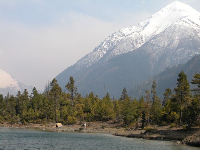 The Makalu – Barun National Park and Conservation Area was established in 1992 as Nepal’s eighth national park. Covering 2,330 sq km, Makalu – Barun is a remote wilderness, with just two small settlements and seasonal herding in high pastures. The area receives few foreign trekkers due to its relative inaccessibility and a journey to base camp is an unforgettable experience. In the forests there are many varieties of orchids and more than 3,000 species of flowering plants. The area protects an abundant wildlife including the endangered red panda, musk deer, Himalayan tahr and leopard. There are more than 400 bird species, some of which are extremely rare.
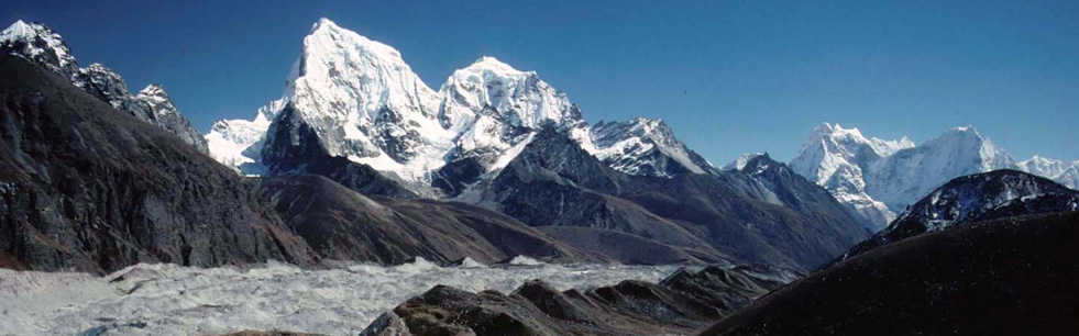
Then of course there are the mountains, Makalu, Everest, Lhotse and Chhamlang that form a stunning backdrop at the head of the Barun Valley. This is an extremely rewarding trek that remains largely untouched by tourism. It is definitely one for the connoisseur of wild places! Our itinerary has been carefully planned to allow for acclimatization to the altitude, and time for further exploration from Makalu Base Camp to Swiss Base Camp (5,120m/16,800 ft) that provides stunning panorama views. There are some long days of 7 to 8 hours walking, some rough trail sections and the effects of altitude will be present.
Detailed Itinerary
Arrival in Kathmandu (1,300m/4,264ft)
On arrival in Kathmandu airport, you will be greeted by our staff and escorted to your hotel room. You may have a rest or take a leisurely stroll in the streets of Thamel. In the evening, there will be a welcome dinner at a traditional Nepalese restaurant serving excellent Nepalese cuisine. Overnight in Kathmandu.
Included meals: Dinner
1
Kathmandu Sightseeing and Trek Preparation
Today, we will visit some significant world heritage sites, including Patan Durbar Square, the religious Pashupatinath temple, Swayambhunath (the Monkey Temple) and the famous Boudhhanath stupa. Later, we will meet our trek leader and guide, check our equipment and meet other group members and discuss the exciting adventure ahead.
Included meals: Breakfast
2
Fly from Kathmandu to Tumlingtar, then drive to Chichila (1,980m/6497ft): 35 mins flight, 3-4 hours drive
After a sumptuous breakfast, we will be transferred to the domestic airport for a short flight to Tumlingtar, which sits on a wide plateau in the Arun valley. We will fly above mountain ranges overlooking snow-capped peaks from Langtang all the way to Mt. Everest, Makalu and Mt. Kanchenjunga. On arrival at Tumlingtar, we will drive along a rough road passing terraced fields and then further up through forests to the village of Chichila, a small Gurung settlement. Overnight camping in Chichila.
Included meals: Breakfast, Lunch, Dinner
3
Chichila to Num (1,560m/5119ft): 6-7 hours
We start walking on a moderate pace through a forest of rhododendron and bamboo followed by oak further along the ridge, through picturesque villages with superb view of the Himalayas including Makalu. After lunch, we will reach a small Sherpa village of Mure from where our walk descends to the village of Num, which is set on a promontory above the Arun River. Overnight camping in Num.
Included meals: Breakfast, Lunch, Dinner
4
Num to Seduwa (1,500m/4922 ft): 6-7 hours
Seduwa is on the opposite side of the valley, so we first descend steeply through terraced fields all the way to Arun Khola and then cross the suspension bridge before a winding ascent up to the other side of the valley to reach Seduwa. The entry checkpoint for Makalu-Barun National Park is in this village. The landscape here is picturesque with tiny terraces planted with corn and barley. Overnight camping in Seduwa.
Included meals: Breakfast, Lunch, Dinner
5
Seduwa to Tashigaon (2,100m/6890ft): 4-5 hours
We continue climbing out of the valley through rhododendron and bamboo then start traversing through terraced rice fields to Manigaon village. From here the trail contours through forest and farmland to reach the Tashigaon School at the entrance to Tashigaon village. This is the last permanent settlement in the valley. We make the long climb on a stone staircase to three corn fields at the top of the village, which is our campsite. Overnight camping in Tashigaon.
Included meals: Breakfast, Lunch, Dinner
6
Tashigaon to Khongma Danda (3,500m/11,483 ft): 6-7 hours
From Tashigaon there is a steady climb through forest, and after a while, it starts to open out with more rhododendrons until we reach a few huts at Chipla. We begin to gain more altitude and leave the green forests behind. After a strenuous uphill climb, where the tree lines declines for the bushes of rhododendron and juniper, we will continue through sparse forests before making a final descent to Khongma. There are no buildings and many of the tent sites are on the sloping hillside. Overnight camping in Khongma Danda.
Included meals: Breakfast, Lunch, Dinner
7
Acclimatization/Rest
It is essential to take a rest day after a rapid ascent of 1400 m the previous day, to help your acclimatization before crossing Shipton La the next day. An optional morning walk along Khongma Danda towards Shipton La is useful to help the acclimatization process by climbing high and sleeping low. Superb views from Khongma looking eastwards towards Kanchenjunga can be witnessed today. Overnight camping in Khongma Danda.
Included meals: Breakfast, Lunch, Dinner
8
Khongma Danda to Dobate: 6-7 hours
From Khongma, the trail climbs steeply along switchbacks with superb views of Makalu and Chamlang and also over to Kanchenjunga in the east. We continue walking along a stone staircase through rhododendron before reaching Shipton La Pass followed by a descent to Kalo Pokhari Lake. We make a climb to Keke La and finally make an easy descent towards the beautiful Dobate valley. Overnight camping in Dobate.
Included meals: Breakfast, Lunch, Dinner
Included meals: Breakfast, Lunch, Dinner
9
Dobate to Yangri Kharka (3,557m/11,670 ft): 6-7 hours
Today, we travel through huge rhododendrons and forests of fir and birch on our way to Yangri Kharka. We descend steeply to the south bank of the Barun River, which is then followed crossing several areas of landslide to arrive at a small village, Yangri Kharka, situated in a meadow at the base of the valley. Beyond the worst of the slide areas, we will get great views of Peak 6 and Peak 7 down the valley today. Overnight camping in Yangri Kharka.
Included meals: Breakfast, Lunch, Dinner
10
Yangri Kharka to Langmale Kharka: (4,410m/14,468ft): 5-6 hours
We pass through yak pastures, lush forests and boulder fields following a moderate walk to the valley. As we are now approaching high altitude, we limit our rate of ascent to ensure that our body has necessary time to acclimatize. We pass Merek as we make our way further up and notice a significant rise in the scenic Himalayan views. Overnight camping in Langmale Kharka.
Included meals: Breakfast, Lunch, Dinner
11
Langmale Kharka to Makalu Base Camp: (4,870m/15,978ft): 6-7 hours
Today is a relatively short trekking day to reach our destination, which affords stunning views of its south face, including Baruntse, Everest and Lhotse. From Langmale Kharka we make our way up to Shersong and eventually to Makalu Base Camp. Majestic Himalayan panorama surrounds us as we make our way to the camp. Overnight camping in Makalu Base Camp.
Included meals: Breakfast, Lunch, Dinner
12
Makalu Base Camp; Day Trip to Swiss Base Camp and return to Base Camp: 4 - 5 hours
Today, we make an adventurous optional 2 hours walk towards the left side from the base camp, first crossing the Japanese camp, then heading through narrow trails on the south side of the Barun valley to reach the Swiss Base Camp (5,120m/16,800 ft). Spending some time at the Swiss base camp with jaw dropping panoramic views, we retreat back to our campsite. Overnight camping in Makalu Base Camp.
Included meals: Breakfast, Lunch, Dinner
13
Morning hike to view point (right side) and trek down to Langmale Kharka: 5 – 6 hrs
Today, after breakfast, we will hike up for about 2 hours, towards our right side, to a view point above the base camp. From the view point above the Makalu Base Camp there are superb views of some of the world’s highest mountains, including Everest, Lhotse, Makalu, Chamlang and Baruntse. Like the previous day, we can see all those picturesque views as seen from the Swiss Base Camp. Then, we will trek down back to base camp, where we will have our lunch. After lunch, we will trek down on a easy trail to our campsite for overnight. Overnight camping in Langmale Kharka.
Included meals: Breakfast, Lunch, Dinner
14
Langmale Kharka to Yangri Kharka : 3 -4 hours
Retracing from Langmale Kharka, we pass Merek and make our descend through the Barun valley leaving behind the yak pastures and lush forests to reach Yangri Kharka. Overnight camping at Yangri Kharka.
Included meals: Breakfast, Lunch, Dinner
15
Yangri Kharka to Dobate : 4 - 5 hours
We descend through rock falls, green forests and valleys from Yangri Kharka, making our way towards Dobate. Following the river banks of Barun, we descend down the trail leaving behind the forests of rhododendrons, fir and birch to reach our stopover point for today. Overnight camping at Dobate.
Included meals: Breakfast, Lunch, Dinner
16
Dobate to Khongma Danda: 5 -6 hours
We begin with a steep climb from Dobate valley to Mumbuk through fir and rhododendron forests before descending through the rock-fall area of Keke La. Crossing the Shipton La, we make our final descent to Khongma. Overnight camping at Khongma Danda.
Included meals: Breakfast, Lunch, Dinner
17
Khongma Danda to Tashigaon: 4-5 hours
Our day begins with a short ascend where we continue to retrace our way through the bushes and the tree lines of rhododendron and juniper are visible again. With a deep descent to Chipla village and a steady walk, we will reach the Sherpa village of Tashigaon. Overnight camping in Tashigaon.
Included meals: Breakfast, Lunch, Dinner
18
Tashigaon to Seduwa: 4-5 hours
Today is a long and steep descent back to civilization and as we emerge from the mountains, there is time to reflect on the stunning journey that we have taken. Leaving the Makalu-Barun National Park and descending the Barun River, we cross the hillside and passing rhododendron and bamboo forests and terraced rice fields, we reach our day’s stop at Seduwa. Overnight camping in Seduwa.
Included meals: Breakfast, Lunch, Dinner
19
Seduwa to Num: 5-6 hours
Trekking further through the forests, the trail goes up and down passing Sherpa villages and dense forests. We steadily descend through the partly forested terrain to the Arun River and finally make our ascend through terraced fields on the opposite valley and reach Num. Overnight camping at Num.
Included meals: Breakfast, Lunch, Dinner
20
Num to Tumlingtar: 6-7 hours
Savoring the vista of Mt. Makalu for the last time, we retrace our footsteps back to the Sherpa village of Mure. Crossing forests of rhododendron and bamboo along the ridge and picturesque village and superb view of the Himalayas, we will reach Chichila village. From here, we will drive back on the same rough road that we came passing terraced fields to reach Tumlingtar. Overnight in Tumlingtar.
Included meals: Breakfast, Lunch, Dinner
21
Tumlingtar to Kathmandu: 50 mins flight
We will fly back to Kathmandu after our fascinating trek in the mountains. On arrival at Kathmandu, we will be transferred to our hotel where we may rest and relax the remaining day. In the evening, there will be a farewell dinner organized by Canadian Himalayan Expeditions on the successful completion of our Makalu Base Camp Trek. Overnight in Kathmandu.
Included meals: Breakfast, Lunch, Dinner
22
Free day in Kathmandu
As a free day in Kathmandu, you may do your last minute shopping to buy some souvenir to take back home. You may also visit the former Royal Palace now converted to a museum today. In the evening you can also go to Thamel pub for some live music or relax at your hotel room. Overnight in Kathmandu.
Included meals: Breakfast.
23
Final departure
Today, your beautiful journey in Nepal has been completed. A representative from Canadian Himalayan Expedition will transfer you to the airport for flight back home.
24
Synopsis
Trip Grading:

Length: 24 days, 20-day trek
Max. Altitude: 16,800 ft. / 5120 m
Begins/Ends in Kathmandu
Land Cost: $4330 (based on five plus participants) Full-service tented 'camping' trek (includes tents, food, guide, staff, etc.)
Apr 05 - April 28, '20
Oct 04 – Oct 27, ’20
Apr 04 - April 27, '21
Oct 03 – Oct 26, ’21
Single supplement: $265 (For hotel room nights in Katmandu and single tent on trek).
Included in the cost of your trip: 20 days trekking including all meals and major equipment; domestic flights, 4 nights accommodation in Kathmandu with breakfast, welcome dinner and farewell dinner; airport/hotel transfers for arrival and departure; Kathmandu sightseeing, services of an experienced trip leader, cook, porters, and local guides. You can also contact Canadian Himalayan Expeditions directly for more information.
You can also contact Canadian Himalayan Expeditions directly for more information.
Synopsis
Trip Grading:
Length: 24 days, 20-day trek
Max. Altitude: 16,800 ft. / 5120 m
Begins/Ends in Kathmandu
Land Cost: $4330 (based on five plus participants) Full-service tented 'camping' trek (includes tents, food, guide, staff, etc.)
Apr 05 - April 28, '20
Oct 04 – Oct 27, ’20
Apr 04 - April 27, '21
Oct 03 – Oct 26, ’21
Single supplement: $265 (For hotel room nights in Katmandu and single tent on trek).
Included in the cost of your trip: 20 days trekking including all meals and major equipment; domestic flights, 4 nights accommodation in Kathmandu with breakfast, welcome dinner and farewell dinner; airport/hotel transfers for arrival and departure; Kathmandu sightseeing, services of an experienced trip leader, cook, porters, and local guides. You can also contact Canadian Himalayan Expeditions directly for more information.
You can also contact Canadian Himalayan Expeditions directly for more information.
Gallery